Introduction
Let me start with something that happened just last week. One of my students — Priya, brilliant girl, but terrified of geography — came to me after class and said, "Sir, I still don't understand why it rains so much in Kerala but the Thar Desert stays dry. They're both in the same country!" That single question made my day, honestly. Because it's exactly the kind of thinking that separates someone who merely memorises facts from someone who actually understands India's climate.
Here's the truth: Indian geography isn't just about drawing maps and remembering capitals. It's about understanding the grand drama happening above our heads — the winds, the pressure systems, the ocean currents — that literally determine whether farmers celebrate harvests or face droughts. The monsoon isn't just weather. It's India's lifeline. It's why our entire economy, agriculture, and water security depend on those clouds rolling in between June and September.
And if you're preparing for SSC CGL or UPSC, this topic is gold. I've seen at least 2-3 questions on monsoon patterns, climate zones, and seasonal variations in almost every exam. Not to mention the interconnected questions about agriculture, water resources, and regional development that all hinge on understanding climate.
So let's do this properly. Not just the what, but the why and how. By the time we're done, you'll see monsoons the way I do — not as a complicated meteorological concept, but as India's most fascinating geographical phenomenon.
Understanding India's Climate System: The Big Picture
Before we dive into monsoons specifically, we need to understand the larger climate system that makes India the meteorological powerhouse it is. Think of it like this: if monsoon is the protagonist of our story, then latitude, altitude, pressure systems, and ocean currents are the supporting cast that makes the whole narrative work.
Why Does India Have Such Diverse Climates?
India stretches from about 8°N to 35°N latitude — that's a massive range. This alone creates variation. But here's what really matters: India's position relative to the Equator and the Tropic of Cancer means different parts experience different pressure systems at different times of the year.
The Tropic of Cancer passes through central India (around Rajasthan, Madhya Pradesh, and Chhattisgarh). This is crucial because the sun is directly overhead here twice a year, creating intense heating. Meanwhile, the Himalayas to the north act like a giant wall, blocking cold winds from Central Asia. The Western and Eastern Ghats funnel air and moisture in specific ways. And don't forget the Arabian Sea and Bay of Bengal — two massive water bodies that moderate temperatures and supply moisture.
So when Priya asked me why Kerala gets more rain than Rajasthan, the answer involved all of these factors working together. It's not random. It's a beautiful, predictable system once you understand the mechanics.
The Pressure Systems That Drive Everything
Now here's where most students get confused, so I'm going to make this simple. In January, when it's winter in the Northern Hemisphere, a high-pressure zone (called the Subtropical High) settles over India. High pressure = descending air = dry conditions. That's why winter (December-February) is mostly dry across most of India, except for a little bit of rain on the southern coasts due to retreating monsoon winds.
But come April and May, the sun moves north, the land heats up like a tandoor oven, and a low-pressure system forms over the Indian subcontinent. Low pressure = rising air = moisture-laden winds are drawn in. This is when the southwest monsoon enters the scene.
Let me give you a memory trick I use with all my students:
"High Pressure = High and Dry, Low Pressure = Low and Wet"
Simple? Yes. But it works every single time. Remember this, and half your confusion about seasonal weather patterns disappears.
The Southwest Monsoon: India's Most Important Season
Okay, this is the star of the show. The Southwest Monsoon (also called the Summer Monsoon) arrives between late May and June and lasts until September. This is when most of India gets its annual rainfall. We're talking about 80% of annual precipitation in many regions. Fail to understand this, and you're missing the backbone of Indian agriculture, water resources, and even urban planning.
How Does the Southwest Monsoon Arrive?
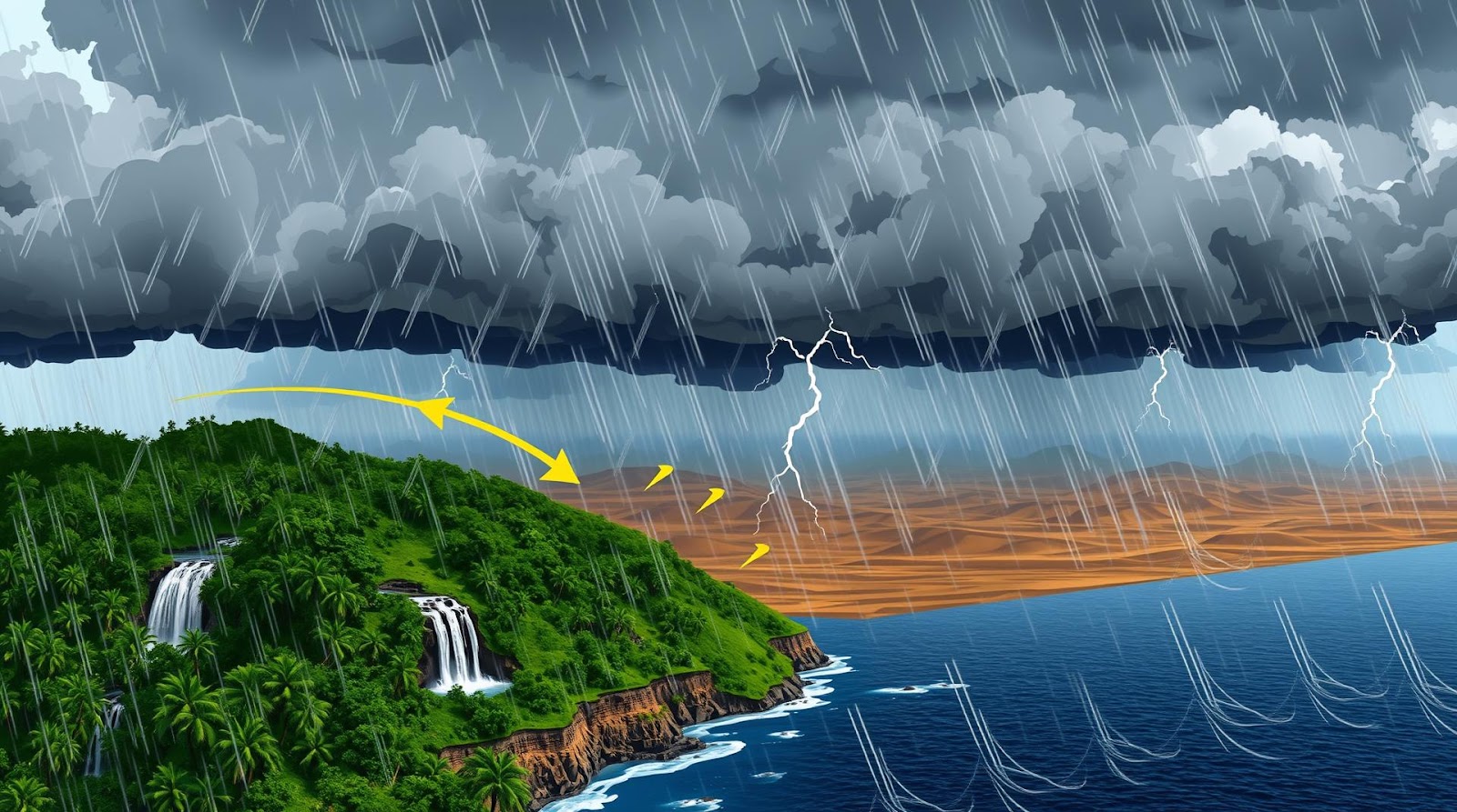
Picture this: It's May, the sun is directly overhead around the Tropic of Cancer. The landmass heats up rapidly, creating a massive low-pressure area over central India, especially around the Deccan Plateau. Meanwhile, the Intertropical Convergence Zone (ITCZ) — imagine it as an invisible belt around the Earth where trade winds converge — also shifts northward, following the sun.
The trade winds from the Southern Hemisphere cross the Equator and get deflected by the Coriolis effect (thanks to Earth's rotation). These winds, now carrying massive amounts of moisture from the Arabian Sea and Bay of Bengal, are drawn toward that low-pressure region over India. And boom — the monsoon arrives.
The winds hit the Western Ghats first, causing orographic rain (rain caused by land barriers). Places like Malabar Coast in Kerala receive 250-350 cm of rain annually. Then the winds continue inland, losing moisture as they go, which is why the rain decreases as you move eastward and inland.
Now, here's something many students get wrong: the Southwest Monsoon doesn't bring rain uniformly. The rainfall is heaviest on the windward side of mountain ranges and significantly lighter on the leeward side. The rain shadow effect is real, and it's why Pune (on the leeward side of the Ghats) gets only 50 cm of rain while nearby Mahabaleshwar gets 250 cm.
The Monsoon's Regional Character
The southwest monsoon has two branches, and this is important for exams. The Arabian Sea branch brings moisture to the western coast and moves inland through the Deccan. The Bay of Bengal branch brings rain to the eastern coast and moves westward and then southwestward into central India.
I always tell students to visualize this as two rainfall highways entering India from opposite sides. The western highway (Arabian Sea branch) is slightly more powerful and brings heavier rain. The eastern highway (Bay of Bengal branch) brings rain to places like West Bengal, Odisha, and eastern India, but by the time it reaches central India, it's already lost most of its moisture.
Which is why the Ganges delta is incredibly fertile (loads of rain from both branches) while the Deccan Plateau is a rain shadow region with moderate to sparse rainfall.
Winter Monsoon and Seasonal Extremes: The Full Picture
Most students focus only on the southwest monsoon and think they're done. But here's where you stand out from the crowd: understanding the complete annual cycle, including the retreating monsoon and northeastern winter winds.
The Northeast Monsoon (October to February)
When the southwest monsoon weakens and retreats (September-October), a completely different wind pattern sets in. The high-pressure system that was over the oceans moves back over the Indian landmass. Cold, dry winds from the northeast — originating from the Tibetan Plateau — flow southeastward across the subcontinent.
Sounds dry, right? And it mostly is. But here's the twist: when these northeastern winds blow across the Bay of Bengal, they pick up moisture. And this moisture brings rain to parts of southern and eastern India — especially Tamil Nadu, coastal Andhra Pradesh, and southern Odisha. So when most of India is experiencing winter dryness, places like Chennai are getting their primary rainfall from this retreating monsoon system.
This is why Tamil Nadu's agricultural calendar is completely different from Punjab's. While Punjab celebrates harvest after the southwest monsoon (Baisakhi festival), Tamil Nadu's main crop depends on the northeast monsoon winds.
Seasonal Extremes and Regional Variations
India's climate doesn't play by simple rules. We have incredible regional variation, and exams love testing this. Let me break it down geographically:
The Western Coast: Incredibly wet. Places like Kochi and Mangalore receive 200-350 cm annually, with most of it during the southwest monsoon. They're almost tropical.
The Deccan Plateau: Rain shadow region. It receives only 50-100 cm annually because the Ghats wring out most of the moisture. Parts of interior Karnataka and Telangana are semi-arid.
The Indo-Gangetic Plain: Moderate rainfall (75-200 cm depending on location). The western parts (Punjab, Haryana) are drier; the eastern parts (Bengal, Assam) are wetter due to the Bay of Bengal branch of the monsoon.
The Himalayan Region: Extremely wet in the eastern parts (Assam, Arunachal Pradesh) — sometimes receiving over 250 cm. The western Himalayan regions (Himachal, Jammu & Kashmir) are drier, with significant winter snowfall.
The Thar and other desert regions: Sparse rainfall, less than 50 cm annually. These are essentially marginal rain-fed regions.
Here's a memory trick for rainfall distribution:
"W for West (Wet), E for East (Extra Wet), D for Deccan (Dry)"
Sounds silly, but it works. Western coast is wet, eastern regions are even wetter, Deccan is relatively dry.
| Region/Zone | Annual Rainfall (cm) | Main Rainy Season | Climate Type |
|---|---|---|---|
| Western Coast (Kerala, Karnataka) | 200-350 | June-September (SW Monsoon) | Tropical |
| Deccan Plateau | 50-100 | June-August (SW Monsoon, weak) | Semi-arid |
| Indo-Gangetic Plain | 75-200 | June-September (SW Monsoon) | Tropical/Subtropical |
| Eastern India (Assam, Bengal) | 150-250+ | June-September (Both Monsoon Branches) | Tropical |
| Thar Desert | <50 | Sparse (July-August) | Hot Desert |
| Southern Coast (Tamil Nadu) | 100-150 | October-December (NE Monsoon) | Tropical/Subtropical |
Climate Classification and Its Practical Importance
Now, if you're reading this for UPSC, you absolutely need to understand how India's climate is classified and why it matters. The Köppen-Geiger climate classification system divides India into several distinct zones, and understanding these isn't just academic — it determines everything from agricultural practices to water management strategies.
India's climates range from tropical wet (Assam, parts of Kerala) to hot deserts (Rajasthan). We have tropical dry deciduous forests in central India, tropical wet evergreen forests in the Western Ghats, and temperate zones in the Himalayas. This incredible diversity is what makes India geographically fascinating and, let's be honest, exam-challenging.
The monsoon system is the primary driver of all these climate zones. Change the monsoon patterns even slightly, and you change entire ecosystems, agricultural zones, and water availability patterns. This is why climate change and monsoon predictions have become such critical topics in contemporary geography and policy discussions.
Why Monsoon Patterns Matter for Your Future
I'm going to be honest with you. Understanding monsoons isn't just about passing exams (though it'll definitely help with that). It's about understanding India itself. The monsoon determines:
Agriculture and Food Security: About 60% of India's agricultural area depends on monsoon rainfall. A weak monsoon means crop failures, farmer distress, and food inflation. A strong monsoon means record harvests and agricultural prosperity. This is why meteorologists obsess over monsoon forecasts, and why the India Meteorological Department's monsoon predictions make headlines every June.
Water Resources and Hydroelectric Power: Dams, reservoirs, and groundwater recharge all depend on monsoon rainfall. The water you drink in urban areas was largely replenished during the monsoon months. Hydroelectric projects that power our cities depend on monsoon-fed rivers.
Regional Development and Migration: Historically, monsoon-dependent regions developed differently than those with more predictable rainfall. This influenced settlement patterns, crop choices, and even migration trends.
Climate Change and Policy: Monsoon patterns are shifting due to climate change. Understanding these systems helps policymakers design better water management, agricultural, and climate adaptation policies.
So when you're studying this for your exam, remember: you're not just memorizing facts. You're understanding the fundamental system that sustains 1.4 billion people.
Quick Revision Table: Key Monsoon Facts at a Glance
| Concept | Details |
|---|---|
| Southwest Monsoon (Main) | Arrives June, lasts until September. Brings 80% of India's annual rainfall. Two branches: Arabian Sea (west) and Bay of Bengal (east) |
| Northeast Monsoon (Retreating) | October to February. Brings rain to southern coastal regions (Tamil Nadu, Andhra Pradesh). Dry winds over most of India |
| Pressure Systems | High Pressure (Winter) = Dry. Low Pressure (Summer) = Wet. This drives seasonal wind reversals |
| Rain Shadow Effect | Windward slopes get heavy rain; leeward slopes are dry. Classic example: Western Ghats vs. Deccan Plateau |
| ITCZ Movement | Intertropical Convergence Zone shifts northward in summer (bringing monsoon), southward in winter |
| Monsoon Onset | Usually reaches Kerala around June 1st, spreads northward. Marks the official beginning of monsoon season |
| Monsoon Withdrawal | Happens gradually from September-October as high-pressure systems dominate again |
There you have it, friend. Indian monsoon and climate in a way that actually makes sense. Remember, the examiners want to see that you understand the system, not just the facts. Show them you grasp WHY Kerala is wet and why Rajasthan is dry, and you'll sail through those geography questions.
Now go ace those exams!
---Practice Questions
A) It originates from high-pressure systems over the Indian Ocean and brings dry winds B) It's caused by the southward movement of the ITCZ and brings moisture-laden winds from the Arabian Sea and Bay of Bengal C) It occurs during winter and is responsible for rain in the Thar Desert D) It begins in March and lasts until May
Answer: B) It's caused by the southward movement of the ITCZ and brings moisture-laden winds from the Arabian Sea and Bay of Bengal
A) The Deccan Plateau is at a higher altitude, which prevents cloud formation B) The Arabian Sea branch of the monsoon loses moisture while crossing the Western Ghats due to orographic rainfall, creating a rain shadow effect C) The Deccan Plateau is too hot for rainfall during monsoon season D) Ocean currents prevent moisture from reaching the Deccan interior
Answer: B) The Arabian Sea branch of the monsoon loses moisture while crossing the Western Ghats due to orographic rainfall, creating a rain shadow effect
A) Punjab and Haryana B) Tamil Nadu and southern Andhra Pradesh C) Western Ghats and Kerala D) Assam and Meghalaya
Answer: B) Tamil Nadu and southern Andhra Pradesh
A) The ITCZ causes the winter monsoon to bring rain to northern India B) The ITCZ shifts northward in summer, drawing southwest monsoon winds toward India, and shifts southward in winter, resulting in the northeast monsoon C) The ITCZ is a permanent feature that doesn't move and controls only the Himalayan climate D) The ITCZ has no significant impact on Indian monsoons
Answer: B) The ITCZ shifts northward in summer, drawing southwest monsoon winds toward India, and shifts southward in winter, resulting in the northeast monsoon
A) Its proximity to the Equator, which brings tropical conditions year-round B) Its location on the windward side of the Khasi Hills, where moisture-laden Bay of Bengal winds are forced to rise and release moisture through orographic precipitation C) Its latitude in the Himalayas, which traps all moisture D) Ocean currents that bring warm water from the Pacific
Answer: B) Its location on the windward side of the Khasi Hills, where moisture-laden Bay of Bengal winds are forced to rise and release moisture through orographic precipitation
Published by Dattatray Dagale • 22 June 2026
.jpg)
.png)


.png)


0 Comments